Mir
Russia Republic of Crimea Annunciation Monastery (Mount Mangup) Map is loading...
{"format":"leaflet","minzoom":false,"maxzoom":false,"limit":50,"offset":0,"link":"all","sort":[""], "order":[],"headers":"show","mainlabel":"","intro":"","outro":"","searchlabel":"\u2026 \u0441\u043b\u0435\ u0434\u0443\u044e\u0449\u0438\u0435 \u0440\u0435\u0437\u0443\u043b\u044c\u0442\u0430\u0442\u044b","default":"","import-annotation":false,"width ":"auto","height":"350px","centre":{"text":"","title":"""link":"""lat":44.59385900000000191312210517935454845428466796875,"lon": 33.80643400000000298177837976254522800445556640625,"icon":""},"title":"","label":"","icon":"","lines":[],"polygons":[],"circles":[ ],"rectangles":[],"copycoords":false,"static":false,"zoom":8,"defzoom":14,"layers":["OpenStreetMap"],"image layers":[] ,"overlays":[],"resizable":false,"fullscreen":true,"scrollwheelzoom":true,"cluster":false,"clustermaxzoom":9,"clusterzoomonclick":true,"clustermaxradius":80, "clusterspiderfy":true,"geojson":"","clicktarget":"","showtitle":true,"hidenamespace":false,"template":"","userparam":"","activeicon": "","pagelabel":false,"ajaxcoordproperty":"","ajaxquery":"","locations":[{"text":"\u003Cb\u003E\u003Ca href=\"/palomnik/%D0% 91%D0%BB%D0%B0%D0%B3%D0%BE%D0%B2%D0%B5%D1%89%D0%B5%D0%BD%D1%81%D0%BA%D0%B8% D0%B9_%D0%BC%D1%83%D0%B6%D1%81%D0%BA%D0%BE%D0%B9_%D0%BC%D0%BE%D0%BD%D0%B0%D1% 81%D1%82%D1%8B%D1%80%D1%8C_(%D0%B3%D0%BE%D1%80%D0%B0_%D0%9C%D0%B0%D0%BD%D0%B3 %D1%83%D0%BF)\» title=\»\u0411\u043b\u0430\u0433\u043e\u0432\u0435\u0449\u0435\u043d\u0441\u043a\u0438\u0439 \u043c\u0443\u0436\ u0441\u043a\u043e\u0439 \u043c\u043e\u043d\u0430\u0441\u0442\u044b\u0440\u044c (\u0433\u043e\u0440\u0430 \u041c\u0430\u043d\u 0433\u0443\u043f)\»\ u003E\u0411\u043b\u0430\u0433\u043e\u0432\u0435\u0449\u0435\u043d\u0441\u043a\u0438\u0439 \u043c\u0443\u0436\u0441\u043a\u04 3e\u0439\u043c\u043e\u043d\ u0430\u0441\u0442\u044b\u0440\u044c (\u0433\u043e\u0440\u0430 \u041c\u0430\u043d\u0433\u0443\u043f)\u003C/a\u003E\u003C/b\u00 3E\u003Chr /\u003E \u003Ca href=\"/palomnik/%D0%A1%D0%B2%D0%BE%D0%B9%D1%81%D1%82%D0%B2%D0%BE:%D0%90%D0%BD %D0%BD%D0%BE%D1%82%D0%B0%D1%86%D0%B8%D1%8F\" title=\"\u0421\u0432\u043e\u0439\u0441\u0442\u0432\u043e :\u0410\u043d\u043d\u043e\u0442\u0430\u0446\u0438\u044f\»\u003E\u0410\u043d\u043d\u043e\u0442\u0430\u0446\u0438\u044f\u003C /a\u003E:\u043f \u0440\u0430\u0432\u043e\u0441\u043b\u0430\u0432\u043d\u044b\u0439 \u043c\u0443\u0436\u0441\u043a\u043e\u0439 \u043c\u043e\ u043d\u0430\u0441\u0442\u044b \u0440\u044c \u0421\u0438\u043c\u0444\u0435\u0440\u043e\u043f\u043e\u043b\u044c\u0441\u043a\u043e\u0439 \u0435\u043f\u0430\ u0440\u0445\u0438\u0438\u0423 \u041f\u0426. \u041c\u0443\u0436\u0441\u043a\u043e\u0439 \u043c\u043e\u043d\u0430\u0441\u0442\u044b\u0440\u044c \u0440\u0430\u0441\u043f\ u043e\u043b\u043e\u0436\u0435 \u043d 20-\u044e \u043c\u0435\u0442\u0440\u0430\u043c\u0438 \u043d\u0438\u0436\u0435 \u0443\u0440\u043e\u0432\u043d\u044f \ u041c\u0430\u043d\u0433\u0443 \u043f\u0441\u043a\u043e\u0433\u043e \u043f\u043b\u0430\u0442\u043e \u0438 \u0441\u043f\u0443\u0441\u043a \u043a \u043d\u04 35\u043c\u0443\u0441\u043f\u043b \u0430\u0442\u043e \u0434\u043e\u0432\u043e\u043b\u044c\u043d\u043e \u0440\u0435\u0437\u043a\u0438\u0439 \u2014 \u043f\u043 e\u0432\u0430\u043b\u0443\u043d \u0430\u043c. \u041f\u043e\u043c\u0435\u0449\u0435\u043d\u0438\u044f \u043e\u0431\u0438\u0442\u0435\u043b\u0438 \u0443\u0441\u0442\u0440\ u043e\u0435\u043d\u044b\u0438 \u0437 \u0433\u0440\u043e\u0442\u043e\u0432 \u043f\u0435\u0449\u0435\u0440\u043d\u044b\u0445 \u0433\u043e\u0440\u043e\u0434 \u043e\u0432 VI \u0432\u0435\ u043a\u0430.","title":"\u0411\u043b\u0430\u0433\u043e\u0432\u0435\u0449\u0435\u043d\u0441\u043a\u0438\u0439 \u043c\u0443\u0436\u0 441\u043a\ u043e\u0439 \u043c\u043e\u043d\u0430\u0441\u0442\u044b\u0440\u044c (\u0433\u043e\u0440\u0430 \u041c\u0430\u043d\u0433\u0443\u 043f)","link":" ","lat":44.59385900000000191312210517935454845428466796875,"lon":33.80643400000000298177837976254522800445556640625,"icon":""}],"image Layers":[]}
44.594348; 33.797729
Russia, Republic of Crimea, Bakhchisaray district, Krasnomaksky rural settlement, Mangup plateau
Republic of Crimea
Russia
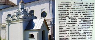
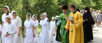
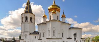
Annunciation Monastery on Mangup
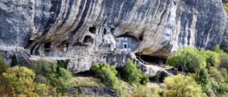
- Orthodox male monastery of the Simferopol diocese of the UOC. The monastery is located 20 meters below the level of the Mangup plateau and the descent to it from the plateau is quite sharp - over boulders. The premises of the monastery are built from the grottoes of cave cities of the 6th century.
History[edit]
In the scientific literature, the monastery about Mangup is described as follows: “You can get to the monastery through an artificial tunnel from a small natural grotto at the foot of the cliff. The passage ends at the edge of the site of a vast, also natural, grotto in the middle part of the cliff. On the eastern side of the grotto there is a church, in the central and northern part of which three graves with shoulders are cut into the floor... Fresco paintings once covered the apse, the arch bordering the altar and the frieze above the arch... Near the entrance to the temple there is a gap into a rectangular room in plan. It most likely was a sacristy or cell. In the western part of the grotto there are four cut-out rooms that probably served as cells. Most likely the monastery should be dated to the first half of the 15th century.” (Mogarichev Yu.M. “Cave cities” in Crimea. Somferopol, 2005, pp. 138-139).
In the beginning. XXI century Monastic life was revived in the monastery, the monastery acquired the name of Blagoveshchensky.
Shrines of the cave monastery
In the monastery there is a revered icon of the Mother of God “The Sign”, carved directly on the rock. There is also the Epiphany Holy Spring.
Patronal feast - Annunciation of the Blessed Virgin Mary - April 7.
Read about other Mother of God holidays:
- Presentation of the Blessed Virgin Mary into the Temple
- Dormition of the Blessed Virgin Mary
- Nativity of the Blessed Virgin Mary
Annunciation Monastery on Mangup
Description[edit]
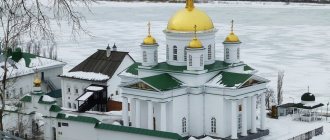
The monastery is located 20 meters below the level of the Mangup plateau and the descent to it from the plateau is quite sharp - over boulders. The monastery itself is located on a hill 210 meters above the rest of the valley and the climb from which to it is quite labor-intensive, but interesting.
At the approach to the monastery, there are flower beds lined with stone, tended by novices. From this height, an excellent landscape opens up and it becomes clear why people create monasteries in such unsuitable places for life.
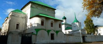
The premises of the monastery are built from the grottoes of cave cities of the 6th century. Modern windows built into small openings in the upper tiers of caves, behind which there are house flowers, look interesting. The monastery has a belfry and a large grotto, apparently once used for meetings.
Compound[edit]
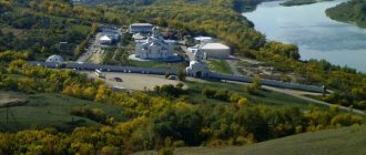
8 km north of the monastery, at the Church of the Nativity of Christ in the village of Krasny Mak, Bakhchisaray district, a monastery courtyard was built.
Location, history of foundation
There is a functioning monastery 25 km from Bakhchisarai. You can get to it in several ways. We'll talk about this a little below. Even scientists do not have exact facts from the history of the foundation of the shrine.
According to some sources, the man-made caves, which later housed the premises of the temple complex, were built by residents of the Principality of Theodoro back in the 11th century. The monastery itself was founded much later. Around the turn of the XIV - XV centuries. The shrine was abandoned for several hundred years.
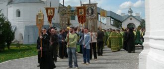
Only in the 90s of the last century did the monks of the Crimean Peninsula take up this task. In 2002, the men's cave monastery was consecrated again. They called it the Holy Annunciation Monastery. Previously, it was simply called “South”, as it is located on the southern slope of the mountain.
Visit
The cave city is located near the Tatar village of Khoja-Sala, located between two other villages - Zalesnoye and Ternovka.
From Bakhchisarai you can get to Mangup by taking a regular bus to the village of Zalesnoye. Before reaching it, you need to ask the driver to stop at the aforementioned lake. And from Sevastopol, buses No. 40 and 109 reach the approaches to Mangup. Getting off at the final stop near the village of Ternovka, you will have to walk several kilometers.
By car, your own or rented, you can reach the parking lot at the lower ticket office along the T0117 and T0105 roads from Bakhchisarai and T0105 from Sevastopol.
The most convenient way to visit Mangup is as part of jeep tours departing from Bakhchisarai and Sevastopol. Their program includes other cave cities.
Since the cave city is located on the territory of the reserve, visiting it is paid. 100 rub. You can pay for the ticket at the box office of both the lower (in the village of Khoja-Sala) and the upper (on the plateau) entrances. Box office hours are 9:00–16:00, but are closed on inclement days. In addition, there is a dress code at the entrance: tourists must have comfortable shoes and hats. In summer the sun is very hot at the top.
At the foot of Mount Baba-Dag, in the village of Khoja-Sala, you can team up and rent a UAZ for six of you for a trip to the Mangup plateau. You can also climb there on foot along the path through the Khoja-Sala ravine. The three-kilometer road to Mangup is marked with blue arrows on the stones and provided with signs. Along the way you will encounter fragments of walls, a necropolis and a basilica.
Reserved lands
Since 1975, a natural monument has been created on Mount Baba-Dag with the fortress located on it to protect the endemics of Crimea. The vegetation here is approximately the same as in the foothills of Crimea. The forest is preserved on the gentle slope of the cuesta mountain, which looks like a fossilized wave.
Small groves remain from the once lush oak forests and pine forests. In them you can find sessile and downy oaks, hawthorn bushes, rose hips, etc.
Occupied by caves and city structures, the flat top is treeless. But here you can also find unusual plants found only in Crimea. In spring, here you can admire the flowering of orchids, yellow asphodels and Crimean orchids. Feather grass, thyme, wild arugula, forest daisies, etc. grow here. Hawkmoths, blueberry butterflies and swallowtails flutter above them. The fauna is represented by lizards and rodents. In these places you can see jays, thrushes, redstarts, robins and other birds.
Important!
Entrance to the territory of the protected city-museum is paid, so you will have to check the opening hours of the ticket office. It depends on the time of year, namely on the length of daylight hours. The entrance fee is low and does not include excursion support, so to hear an interesting story, it is better to come to Mangup with a knowledgeable guide.
What to see on the Mangup plateau
Numerous caves carved into the rocks served as the lower tier of the city. They had utility and living rooms. Above them towered houses that had a more familiar appearance. All this was surrounded by strong defensive walls. From the princely castle in the citadel, only the remains of the walls remained. Tourists do not leave here without taking a photo in front of the magnificent doorway, decorated with amazing carvings. From the bizarre two-story cave Drum-Koba you can admire incredible, breathtaking views. With the peak of Baba Dag dominating three valleys and two rivers, there is a lot to see. Other preserved caves of the rock city are no less interesting.
Legends of Mangup
Everyone who comes here will certainly hear about the famous Mangup boy. All storytellers interpret this legend differently, but agree on only one thing. Everyone says that tourists who meet the hero of this sad and eerie story are in danger of premature gray hair and, perhaps, even madness from the horror caused by this meeting.
In one version, the local mysterious ghost appears as the last prince, heir to the lost principality. The Turks wanted to capture a teenage boy, make him a slave, force him to betray the Orthodox faith, and convert to Islam. The prince, who did not want such a fate, threw himself from a high cliff. And now his spirit wanders at night through the empty caves of the city.
Another legend says that the boy was very young. He turned out to be the last living person, the only survivor of the horrific massacre carried out by the Turks. An unfortunate ghost walks the streets of the city every night. He is looking for his dead parents and constantly cries.
There is another, more rational version. She says that the ghostly boy was simply invented. This was done by the leaders of archaeological excavations carried out at the site in the 60s of the 20th century. They deliberately told scary stories to discourage students participating in these excavations from risky night walks through the ruins. Indeed, even in daylight, fragile rocky ledges and the remains of already collapsed caves can be dangerous for an unwary traveler.
History of life of the rock city
At first glance, the cliff side of the cuesta seems inaccessible and inconvenient for life. In fact, it has been inhabited by people since ancient times. Numerous springs flow from the slopes of Baba-Dag, which make life possible in this peculiarly harsh place. And now, after the spring melting of the snow, there are up to 15 of them. Archaeological research suggests that the first owners of the fortress city were the indigenous inhabitants of the peninsula - the Tauri. The oldest evidence of their presence on the Mangup plateau dates back to the 1st millennium BC. e.
After them, in the 3rd–4th centuries AD, the mountain belonged to the Scythian-Sarmatians. By the 4th century, settlements of the Goths and Alans were established here. In the second half of the century, the construction of fortifications of the city began, which by this time became the capital of Crimean Gothia (the country of Dori). The city at that time was called Doros. A large basilica built in the 6th century makes it the center of the Gothic diocese. In the 7th century, Mangup captured the Khazar Khaganate. The story that followed this event was included in the life of the saint revered in these places - John of Goth (Goth). A revolt led by Saint John returned him to the country of Dori. After this, Doros was again captured by the Khazars, the Monk John was caught and imprisoned in the city of Fulla. Soon he fled from there, and the fortress was again recaptured by Christians.
In the 8th century, Doros was again the center of the Gothic diocese. Since the 13th century, it has been the capital of the late Byzantine principality, called Theodoro (“given by God”). The city at that time was also most often called Theodoro. At this time it acquired impressive fortifications. Majestic citadel structures and numerous basilicas were erected. In 1475, the coast and mountain fortresses of the peninsula were captured by Ottoman troops. The capital of the small mountain principality held its defense longer than other fortresses. She resisted the Turks for more than half a year. Only by cunning and cunning did they manage to break the resistance of the rebellious fortress. Enraged by the stubborn resistance, the Turks did not spare anyone in it. Later, until 1774, a Turkish garrison was based in Mangup. In 1790, the city was abandoned by its last inhabitants - a small community of Karaites. The Russian Empire did not see strategic value in the ancient fortress standing in the middle of the peninsula. Now it is a monument of history and nature.
Masterpieces from God and man
Few ancient buildings have survived to this day, but even those that you can see with your own eyes make a great impression. From the side of the Kapu Dere ravine, the main gate leads into the city, above which there are tombs. In fact, the very name of the ravine is translated as “Gateway”. Immediately outside the gate there was an octagonal temple, a Christian necropolis, a mosque and a monastery. The wide variety of religions is due to the fact that the city has changed owners several times.
Most of the buildings are completely destroyed
On the Teshkli-Burun ledge there is the cave complex “Drum-Koba” - one of the most spectacular areas of the city. Firstly, this is the largest cave on Mangup. Secondly, it has an unusual column. If you hit it several times, the sound will be similar to drumming - hence the name of the cave. It is believed that in ancient times the room served as a prison.
There are many karst voids in the local mountains
Several cave temples have been preserved on the mountain. In some places you can even see drawings on the walls. There were also traditional churches here, such as the Church of St. Constantine with a necropolis. True, only the foundations of the buildings remained. On the central square there was a princely palace and a basilica. There was also a synagogue-kenasa, in which Karaites prayed. The Karaite necropolis has survived to this day. The list of city attractions is completed by the cave monastery on the Chufut-Cheorgan-Burun ledge.
One of the options to get to Mangup-Kale
Mangup-Kale is not only an archaeological site, but also a complex natural monument of national importance. It was founded in 1975. The unique landscape is valuable. The local mountains are rich in karst voids. The length of the largest - Mangup cave - reaches 230 meters. In total there are more than 80 small grottoes and canopies. In the period from the 5th to the 18th centuries, a large number of artificial caves were built, which were used both for housing and for household needs.
Mysterious name
The meaning of the mysterious word “Mangup” has long worried the minds of historians and scientists. No one knows how long it has been associated with this place. There is a version that it has existed since the time of the Tauri. There are surprisingly many different interpretations of it. It is translated from different languages, looking for consonances and suitable meanings. It sometimes sounds like “full of caves”, sometimes like “a great hill.” From the German language spoken by the Gothic population, it stands for “mann” (man) and “gup” (mountain peak). The medieval Ottoman traveler-writer Evliya Celebi says that this word is consonant with the Arabic “mankub” (ill-fated). According to his testimony, the Turks called the hard-won fortress that had long resisted them “ill-fated,” “cursed.”